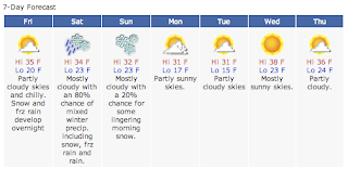
Forecasts for Saturday's weather event changed from snow and ice to primarily an ice storm on Thursday's late-evening newscasts. Thursday was also the final night of the November "sweeps" - the Nielsen Media Research ratings period.
First, the official "Hazardous Weather Outlook" statement issued at 5:37 a.m. from the National Weather Service forecast office in Valley, Neb.:
Freezing rain or sleet will develop over the area after midnight, possibly beginning as a period of light snow. Glazing is expected by daybreak with significant ice accumulations possible by mid-Saturday morning. A winter storm is in effect from late tonight through Saturday evening.
Freezing rain or sleet should change to rain Saturday. This changeover should occur in the morning along and south of Interstate 80, and by early afternoon over the rest of the area. Additional glazing can be expected in the morning. The precipitation could change back to freezing rain or freezing drizzle Saturday night before changing to light snow or flurries early Sunday. At this time, freezing rain or sleet appear to be the main weather hazards from this system.
The exact path of the storm and the timing of the precipitation switch are still somewhat uncertain.
And the late-evening TV forecasts (in alphabetical order):
 KETV Chief Meteorologist Bill Randby led off the newscast by emphasizing that there was still a whole day to "analyze, assess and prepare" for a blast of winter weather on Saturday. His initial forecast graphic emphasized freezing rain and rain.
"Noon to 6 will be rain but from 6 a.m. to noon it's that band of ice," Randby said, referring to a 75-mile wide band on his forecast map.
In his main weather segment, Randby said forecasts for a quarter to a half-inch of freezing rain on Saturday morning, followed by a quarter to half an inch of rain on top of that, has him worried.
 "If that happens, that wouldn't be so bad," Randby said. "My worry is that somebody
- probably up here (pointing to an area in northeast Nebraska and northwest Iowa) - gets stuck in just freezing rain for the duration and has power outages and trees down and power lines down."
Randby said the stage is set for a "very nasty Saturday morning in Omaha," but then added, "if our computer models are true to what they're saying tonight, we'll be spared because we'll get above freezing in the afternoon. (We) shouldn't then have power line issues and trees coming down."
 KMTV Chief Meteorologist Ryan McPike,
 whose forecast segment always leads off the late-evening newscast, emphasized that several weather systems will converge on the Midwest, putting the "First Warning Threat Tracker" in the orange, or highest level.
McPike said to expect frozen precipitation - snow or sleet, possibly changing to freezing rain, sometime after 4 or 5 a.m. Saturday morning - followed by rain around noon.
"Here's the setup: the storm track (is) very close to Omaha," he said. "It looks like it will be just south or right over the top of us."
More details on the forecast are posted on the station's weather blog.
 KPTM Chief Meteorologist Tyson Pearsall
 told viewers in his main weather segment to expect a little bit of snow through the overnight hours in the Omaha metropolitan area, followed by freezing rain.
Pearsall said Omaha will receive its heaviest precipitation - in the form of freezing rain - between 6 a.m. and noon on Saturday.
"Yes, we could see some snow here in the Omaha metro, but the bigger concern right now is the ice," Pearsall said.
 WOWT Chief Meteorologist Jim Flowers
 led off his main weather segment with a follow-up to the two computer forecast models he referred to in his forecast on Wednesday.
"Tonight, those same models are in much better agreement in terms of the type and amounts of precipitation," he said. "There could be a little bit of snow or ice pellets at the beginning, but the amounts are insignificant compared to the amounts of freezing rain and rain (that are) forecast."
Flowers said around 4 or 5 a.m., light snow, possibly mixed with ice pellets, will be falling in Omaha. But about an hour later, freezing rain takes over.

"Then the system begins lifting on to the northeast," Flowers said. "As it does so, we expect a changeover to rain by about 10 or 11 a.m. from Omaha on toward the south."
Flowers said the station's in-house weather computer model is forecasting about a third-of-an-inch of ice for Omaha.
Read more about the forecast on the station's weather blog.


